Do not hesitage to give us a call. We are an expert team and we are happy to talk to you.
+91 70370 17755
+91 84692 31189
info@nomadicworld.co.in


The Annapurna Circuit Trek is renowned as one of the most spectacular trekking routes in the world, offering an unparalleled mix of natural beauty, cultural diversity, and adventure. Beginning in the lush, subtropical lowlands of Nepal, trekkers are immediately immersed in vibrant landscapes dotted with terraced fields, dense forests, and charming villages. As the trail ascends, the scenery transforms into alpine forests, rugged cliffs, and serene river valleys, providing a continuous feast for the eyes and numerous opportunities for photography and nature appreciation.
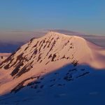
One of the trek’s most thrilling highlights is the Thorong La Pass (5,416 m), the highest point on the circuit. Crossing this pass is both a physical challenge and a spiritual journey, rewarding trekkers with panoramic views of towering snow-capped peaks, deep valleys, and high-altitude deserts. The route is dotted with culturally rich villages such as Manang, Chame, and Muktinath, where centuries-old monasteries and sacred temples offer insights into the unique Himalayan lifestyle and traditions. Muktinath, in particular, is a revered pilgrimage site that beautifully blends spirituality with the raw beauty of the mountains.
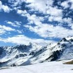
Throughout the trek, adventurers encounter a remarkable diversity of landscapes—from glacial lakes and alpine meadows to barren highlands and cascading waterfalls. Wildlife enthusiasts may also spot Himalayan species like snowcocks, blue sheep, and colorful birds along the trail. The Annapurna Circuit is a journey that goes beyond physical trekking; it’s an immersive experience of Nepal’s natural wonders, traditional culture, and the invigorating spirit of the Himalayas. Whether you are a seasoned trekker or a passionate explorer seeking your first high-altitude adventure, the Annapurna Circuit promises a life-changing journey filled with challenge, discovery, and awe-inspiring scenery.
Altitude: Kathmandu– 1300 m.
Arrive at Tribhuvan International Airport, Kathmandu, where our team will warmly welcome you and transfer you to your hotel. Take the evening to relax, adjust to the altitude, and soak in the vibrant energy of Kathmandu, a city steeped in culture and history.
Stroll through the bustling streets of Thamel, enjoy local cuisine, or prepare your gear for the trekking adventure ahead. The colorful markets, temples, and lively atmosphere offer a gentle introduction to Nepal before you step into the high Himalayas.
Drive Distance: 250 Km.approx. | Drive Duration: 9-10 hrs approx.| Altitude: Chame – 2650 m. | GPS DATA
Embark on a scenic drive from Kathmandu to Besisahar, passing lush valleys, terraced farms, and riverside villages that hint at the adventure to come. Continue winding up the Marsyangdi Valley to Chame, the district headquarters of Manang, which sits at 2,670 m.
This is your first introduction to the Annapurna region’s unique landscapes. On arrival in Chame, settle into a cozy tea house and enjoy your first taste of the tranquil Himalayan village life, preparing for the trek ahead.
Spend the day acclimatizing to the gradually increasing altitude. Take short hikes around Chame, visit local villages, and enjoy panoramic views of the Annapurna and Lamjung ranges.
This is also an ideal day to interact with residents, observe traditional lifestyles, and allow your body to adjust to the high-altitude conditions. Proper acclimatization today will make the trek safer and more enjoyable in the days to come.
Trek Distance: 15 km approx. | Trek Duration: 7-8 hrs approx. | Altitude: Pisang– 3330 m. |GPS DATA
Begin the trek toward Pisang, ascending through alpine forests and past small villages. The trail meanders alongside the Marsyangdi River, offering sweeping views of terraced fields and towering peaks like Annapurna II and Champe Himal.
Pisang is a picturesque village dominated by its ancient monastery and stone houses, where you can rest and enjoy the serene surroundings. The contrast between green lower valleys and rugged mountain terrain becomes more pronounced as you climb.
Trek Distance: 16-17 km approx. | Trek Duration: 6-7 hrs approx. | Altitude: Manang– 3520 m. | GPS DATA
The trail gradually ascends through the villages of Ghyaru and Ngawal, offering spectacular views of Gangapurna, Annapurna III, and Pisang Peak. Enjoy the quiet beauty of alpine meadows and the changing landscapes of high-altitude Nepal.
Reach Manang, a cultural hub with traditional stone houses and mani walls. This village offers modern tea houses and serves as an important stop for acclimatization before ascending higher passes.
Take a well-earned rest day to let your body adjust to the high altitude. Explore Manang’s local trails, monasteries, and cultural sites, or take a short hike to Dhumba Lake or Gangapurna Glacier for stunning scenery.
Hydrate, relax, and enjoy the alpine environment while preparing for the more strenuous days ahead. Proper acclimatization today ensures a safer and more comfortable journey over Thorong La Pass.
Trek Distance: 10 km approx. | Trek Duration: 5-6 hrs approx. | Altitude: Shree Kharka – 4060 m. | GPS DATA
Begin trekking through Dingboche and the surrounding high-altitude fields, passing chortens, prayer flags, and yak herders. The trail winds gently upward, giving panoramic views of Ama Dablam and Cholatse.
Arrive at Shree Kharka, a quiet alpine settlement, where you can rest and enjoy the peaceful mountain surroundings. The day helps your body adapt to altitudes above 4,000 m.
Trek Distance: 8 km approx. | Trek Duration: 5-6 hrs approx. | Altitude: Tilicho Base Camp -4150 m. | GPS DATA
Trek through rugged terrain toward Tilicho Base Camp, crossing streams and moraines with towering peaks as your backdrop. The trail gradually ascends toward the base of Tilicho Peak, offering views of snowfields and glaciers.
Arrive at the Base Camp and take in the stark beauty of the surrounding Himalayas. This area serves as a staging point for the excursion to Tilicho Lake, one of the highest lakes in the world.
Trek Distance: 24 km approx. | Trek Duration: 10-12 hrs approx. | Tilicho Base Camp to Tilicho Lake – 8 Km. (Trek Duration: 4 hrs approx.) | Tilicho Base Camp to Shree Kharka– 8 Km. (Trek Duration: 4 hrs approx.) | Altitude: Tilicho Lake – 4900 m. | Shree Kharka – 4060 m. | GPS DATA
Embark on a day hike to Tilicho Lake, trekking along rocky trails and glacial streams. The turquoise lake, nestled below Tilicho Peak, provides one of the most dramatic alpine settings on the circuit.
After spending time at the lake, retrace your steps back to Shree Kharka, reflecting on the incredible scenery and rewarding yourself with warm hospitality at the tea house.
Trek Distance: 12 km approx. | Trek Duration: 7-8 hrs approx. | Altitude: Yak Kharka–4100 m. | GPS DATA
Descend gently from Shree Kharka toward Yak Kharka, passing alpine meadows dotted with grazing yaks and small settlements. Enjoy clear views of Annapurna III, Gangapurna, and Tilicho Peak along the way.
Yak Kharka is a high-altitude pasture village, perfect for an overnight stay. The tranquility and surrounding mountains make it a peaceful stop before the long ascent toward Thorong La Pass.
Trek Distance: 8 km approx. | Trek Duration: 5-6 hrs approx. | Altitude: Thorongphedi – 4500 m. | GPS DATA
Begin the challenging trek toward Thorong Phedi or High Camp, the base for the Thorong La Pass crossing. The trail becomes steeper, with rocky paths and glacial streams, preparing your body for the high pass ahead.
Arrive at High Camp, where the dramatic views of Thorong Peak and the surrounding ranges make the effort worthwhile. Rest and prepare for the early morning crossing of Thorong La.
Trek Distance: 20 km approx. | Trek Duration: 710-11 hrs approx. | Altitude: Thorong La – 5416 m. | Muktinath -3800 m. |GPS DATA
Start before sunrise to cross Thorong La Pass (5,416 m), one of the highest trekking passes in the world. Witness the panoramic Himalayas as you carefully traverse the rocky and snowy path.
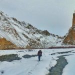
Descend into the sacred valley of Muktinath, famous for its temple and natural springs. The contrast between snow-capped peaks and arid Mustang landscapes is truly breathtaking.
Drive Distance: 21 Km.approx. | Drive Duration: 10-11 hrs approx. | Altitude: Jomsom– 2700 m. | GPS DATA
Descend further through the Mustang region, passing traditional villages and arid landscapes toward Jomsom, a small town on the Kali Gandaki River.
The trail showcases the transition from high alpine terrain to the drier, lower Mustang valley, offering a glimpse into the diverse ecology and culture of the Annapurna Circuit.
Drive Distance: 158 Km.approx. | Drive Duration: 8-9 hrs approx.| Altitude: Pokhara – 822 m.
Take a scenic drive or short flight from Jomsom to Pokhara, passing deep gorges and wide river valleys. Arrive in Pokhara, the gateway to the Annapurna region, and enjoy the comforts of the city.
Relax by Phewa Lake, explore local markets, or simply unwind after the trek. Pokhara’s stunning lakeside views provide the perfect backdrop to celebrate the journey.
Overnight Stay: Hotel in Pokhara
After breakfast, transfer to Pokhara airport or onward destinations. Reflect on the unforgettable landscapes, cultural experiences, and Himalayan adventure you’ve just completed.
Take memories of the Annapurna Circuit with you, knowing you’ve traversed one of the most iconic trekking routes in the world.
End of Trek
Batch 1: 15 Mar – 29 Mar ( Available )
Batch 2: 21 Mar – 04 Apr ( Available )
Group Size 15
Batch 1: 11 Apr – 25 Apr ( Available )
Batch 2: 18 Apr – 02 May ( Available )
Group Size 15
Batch 1: 09 May – 23 May ( Available )
Batch 2: 16 May – 30 May ( Available )
Group Size 15
1. Pickup from Kathmandu airport.
2. Day 1 Hotel Stay in Kathmandu with Breakfast.
3. Day 14 Hotel Stay in Pokhara .
4. Day 2 to 13 Accommodation in the Teahouse (Double / Triple sharing Basis).
5. Three meals (Breakfast, Lunch & Dinner) a day during the trekking (open menu to choose one item per meal from the menu). Order more at your own cost.
6. All meals Kathmandu to Pokhara from Day 2 Packed Breakfast to Day 14 Lunch.
7. All paperwork and trekking permits (National Park Permit, TIMS).
8. A Mountaineering Course and First Aid Certified Trek Leader and Local Experienced guide.
9. An Exhaustive First Aid Kit, including a portable oxygen cylinder, to handle any medical emergencies that may arise during the trek.
10. Achievement certificate (Digital).
11. Transportation Kathmandu to Chame and back to Pokhara.
12. Cloakroom facility available at the base camp (Pokhara) for additional luggage.
1. Meals during road journeys and Hotel Stay in Kathmandu and Pokhara.
2. Any expense incurred for Personal Purposes.
3. Any expense not specified in the inclusion list is not included in the package.
4. We would like to inform you that should you choose to withdraw from the trek, we will be unable to provide reimbursement for any costs related to accommodation or meals.
5. Outdoor Insurance (Mandatory).
6. Mule or Porter to carry Personal Luggage.
7. Emergency evacuation, Hospitalization Charges, etc.
8. Offloading Bag.
9. Wifi, charging Phone, Batteries and hot Shower, Water bottle.
10. Nepal entry visa (USD 40-45 approx., Bring Two Passport Size photos) only for foreigners. (Not for Indians)
11. Unforeseen costs due to weather conditions, etc.
12. Extra night accommodation in Kathmandu or Pokhara.
A) We have implemented a special cancellation policy:
Payment & Booking Policy
A booking fee of ₹10,000 is required to confirm your spot. The remaining trek fee must be paid at least 30 days before the trek start date. If the full payment is not received on time, your booking may be cancelled. The ₹10,000 booking fee is non-refundable under any circumstances.
Our cancellation policy applies to the entire trek fee, not just the booking amount. For any questions or assistance with payment, feel free to contact us.
B) Rescheduling Policy
Rescheduling Within the Same Trip or Changing the Trek
Rescheduling is subject to availability.
Trek costs may vary depending on the location and will be adjusted accordingly.
Guests have the option to reschedule their trek and utilise the amount paid within 2 years.
Guests may also transfer their booking to another person, provided the new participant meets all eligibility, fitness, and document requirements for the trek.
Please ensure you bring all essential items with you:
Trekking Gear:
Footwear:
Clothing:
Toiletries:
Utensils:
Miscellaneous:
Yes, prior high-altitude trekking experience is recommended. Annapurna Circuit Trek is a moderate to difficult trek, with steep ascents, long walking days, and high altitude. You should have good physical fitness and mental endurance.
Tribhuvan International Airport (KTM) in Kathmandu is Nepal’s only international airport.
Direct International Flights: Available from major cities like Delhi, Mumbai, Kolkata, Bangalore, Bangkok, Dubai, Doha, Singapore, Istanbul, Kuala Lumpur, Hong Kong, and Guangzhou.
From India:
Direct flights from Delhi (~1.5 hrs), Mumbai (~3 hrs), Kolkata (~1.5 hrs), Bangalore (~4 hrs).
Airlines: Air India, Indigo, Nepal Airlines, Vistara, Buddha Air (domestic within Nepal).
✈️ This is the fastest and most convenient way for international trekkers.
Several land border crossings connect India with Nepal.
Popular entry points:
Sunauli–Bhairahawa Border (Uttar Pradesh → Lumbini, Nepal)
Raxaul–Birgunj Border (Bihar → Nepal)
Kakarbhitta Border (West Bengal → Eastern Nepal)
Banbasa–Mahendranagar Border (Uttarakhand → Nepal)
From these border towns, buses, jeeps, and shared taxis are available to Kathmandu (6–12 hours).
🚍 Indian travelers often prefer this if coming from UP, Bihar, or Bengal.
No direct train to Kathmandu, but you can take a train to Gorakhpur (UP, India).
From Gorakhpur:
Taxi/bus to Sunauli Border (~3 hrs)
Cross into Nepal and take a bus/shared jeep to Kathmandu (~8–10 hrs)
This option is cheaper but time-consuming and tiring.
Yes – Everest Link WiFi available at tea houses (paid). Mobile networks (Ncell/Nepal Telecom) work in some areas.
Yes, it’s completely safe for solo and female trekkers. We ensure a professional, respectful environment with trained guides, group support, and safe camping practices.
Children (10+ years) can join with proper fitness and enthusiasm
Senior citizens can participate if they are in good health and medically cleared for high-altitude trekking.
We recommend consulting a doctor before booking.
Pre-monsoon (March–May) and post-monsoon (Sept–Nov) are best for clear skies and stable weather.
Yes, but winter is very cold (−15°C to −20°C at night) and monsoon has heavy rains with cloud cover and leeches at lower altitudes.
Yes, two permits are required:
TIMS Card (Trekkers’ Information Management System)
ACAP (Annapurna Conservation Area Permit)
High, since the trek goes above 5,000m. Proper acclimatization and hydration are crucial.
Helicopter evacuation is available (insurance required). Most villages have health posts.
Yes, with high-altitude helicopter evacuation coverage up to 6,000 m.
Yes, but at extra cost. Bring a power bank.
Feel free to reach out to our team via info@nomadicworld.co.in OR Contact us We’re here to help you prepare for a safe, enjoyable, and memorable Himalayan experience.


WhatsApp us
")